
Geophysics, Subsurface & Pile Testing
NDT Corporation applies advanced geophysical and subsurface testing methods, supported by state-of-the-art equipment to provide valuable data on subsurface conditions. This allows our clients to make informed decisions and reduce the chance of costly issues.
Testing services may include identifying unknown foundations or subsurface features, as well as documenting soil layering and material composition. NDT Corporation’s role is focused on data collection and measurement, providing objective results that can be used by owners, engineers, and consultants in their project planning and decision-making processes. All testing is performed in accordance with applicable standards and regulatory requirements.
NDT Corporation is committed to delivering high-quality testing services with a strong emphasis on accuracy, consistency, and attention to detail. Each project is approached with care to ensure data is collected efficiently and documented clearly, supporting the needs and objectives of the project team.
METHODS
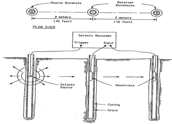
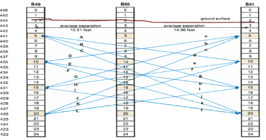
Cross-Hole Compressional and Shear Wave Measurements
Cross-hole testing is the gold standard for seismic site characterization, this method generates high-resolution 2D and 3D velocity maps to determine the precise mechanical properties—such as Poisson’s ratio and Young’s modulus—of specific geologic layers (soil and rock).
This method is used to evaluate soil conditions between multiple boreholes using a cross-hole seismic methodology. Seismic compressional and shear wave velocities are measured as waves travel through the soil from one borehole to another.
The recorded wave velocity data is used to classify subsurface materials based on their mechanical properties. These measurements are compiled into a velocity profile that identifies higher- and lower-velocity soil layers.
Because wave paths cross between boreholes, the data can also be used to detect horizontal and vertical variations in subsurface conditions. Localized high- or low-velocity zones may indicate discontinuities or changes within the soil strata.
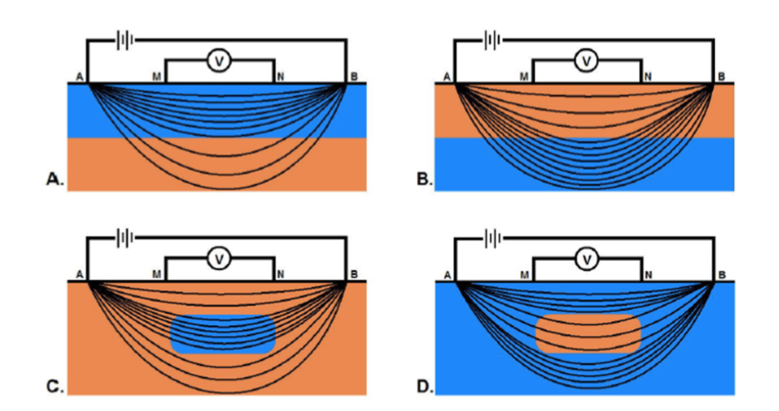
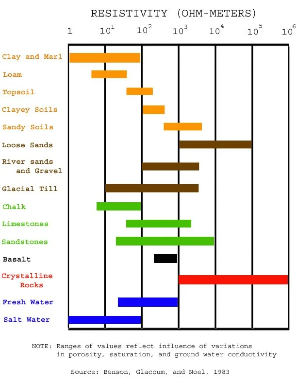
Electrical Soil Resistivity
Electrical Soil Resistivity measures how strongly the ground resists the flow of electrical current. It provides a quantitative value (in ohm‑meters) that describes how well the soil can conduct electricity as a function of depth and location. All equipment is portable including conductive stakes, cables, power supply, resistivity meter and stationing tools for accurate layout of the survey area.
This test helps identify:
Design and verify grounding/earthing systems for electrical installations, substations, and lightning protection.
Assess soil corrosivity for buried structures like pipelines and foundations.
Essential for locating groundwater tables.
Determine seepage/leaks in earthen levees and canals
Contaminant plume migration
Mapping peat/muck deposits.
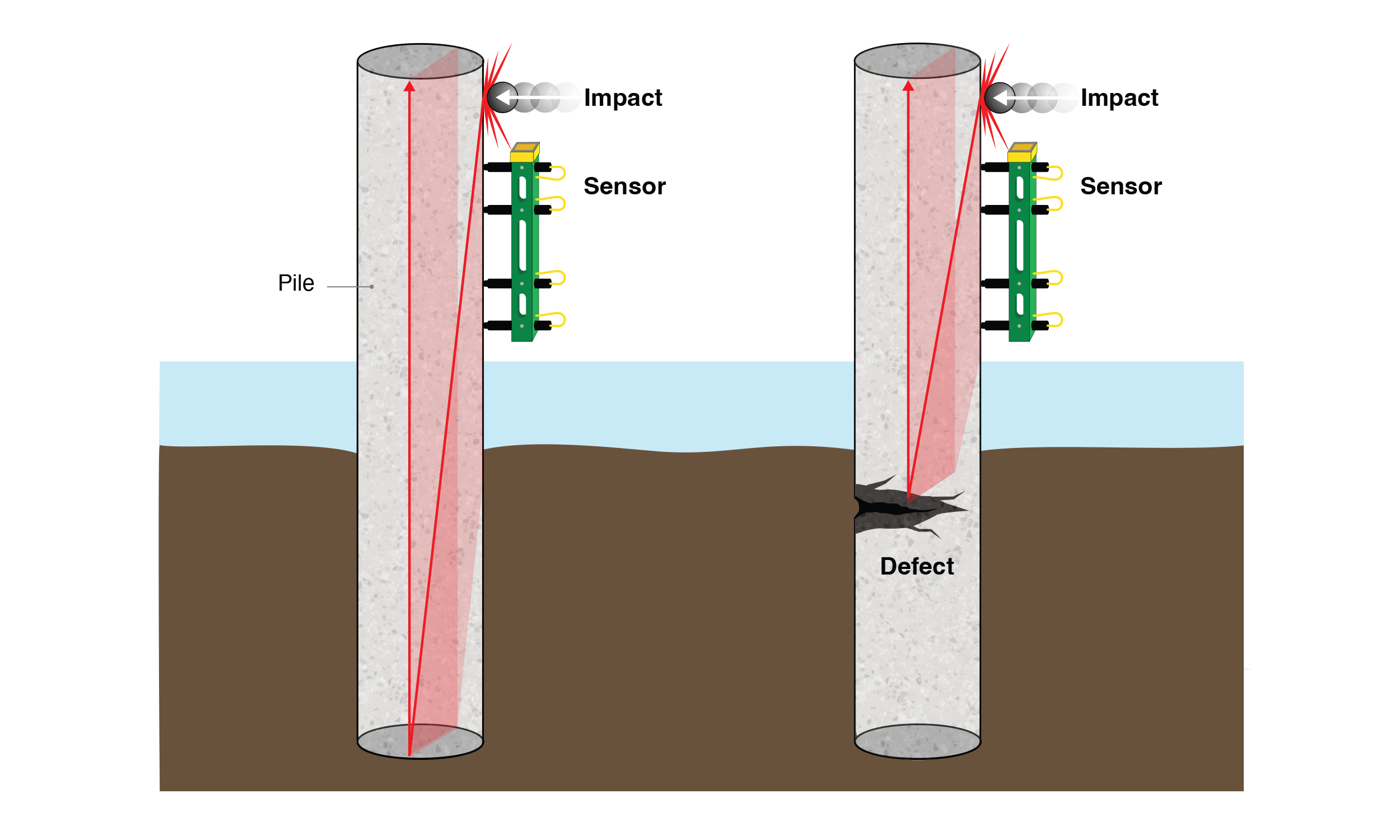
Pile length testing is used to determine the length of steel, timber, and concrete piles using the Pile Integrity Test (PIT) method.
PIT is also commonly referred to as sonic integrity testing, sonic reflection, or sonic echo testing. PIT also a lateral deflection component and load capacity. NDT Corporation provides the length data for timber, steel and concrete piles.
The method works by applying a small hammer impact at the top of the pile and measuring the time it takes for the resulting stress wave to travel to the bottom of the pile and return to the surface. Based on this travel time, the length of the pile can be determined.
PIT testing can also identify significant changes along the pile length that may indicate damage or other internal defects.
Shallow Seismic Refraction
We utilize seismic energy to profile the depth and geometry of the soil and bedrock surfaces (layer thicknesses) for shallow engineering projects.
Applications include:
Ideal for determining depth to bedrock and the strength of that layer
Create a continuous bedrock and soil profiles (for new pipeline placements).
Quantify soil stratigraphy and groundwater conditions
Determine scour vulnerability for overwater bridges
Determine rock “Rip-ability” for contractors tasked with highway cut/fill efforts.
Parallel Seismic Data
Parallel seismic testing involves collecting seismic data using a borehole placed next to a pile. During testing, a signal is generated at the top of the pile, and the pile itself is used to carry that signal downward.
The time it takes for the signal to travel from the top of the pile to its base is measured. Because the signal travels faster through the pile than through the surrounding soil, measurements recorded in the nearby borehole can be used to identify the depth of the pile and locate the pile tip.
Pile Length Testing – Sonic Echo
Vertical Seismic Profiling (VSP)
Vertical Seismic Profiling (VSP) is a borehole method for directly measuring in situ characteristics of subsurface layers and can generate images the areas around existing boreholes. It records the velocity of seismic waves through the soil layers at multiple depths to create high‑resolution velocity profiles that complements surface seismic and other geotechnical data.
Benefits’ to this test method include the ability to:
Measure compressional and shear wave velocities in depth to characterize rock and soil stiffness and layering.
Provide a precise time–depth relationship that links subsurface conditions to surface seismic data for more reliable interpretation.
Generate high-quality images of structures/anomolies near the borehole, improving confidence in identifying faults, interfaces, and stratigraphic features.
Use boreholes, minimizing additional disturbance to site operations from excavting.
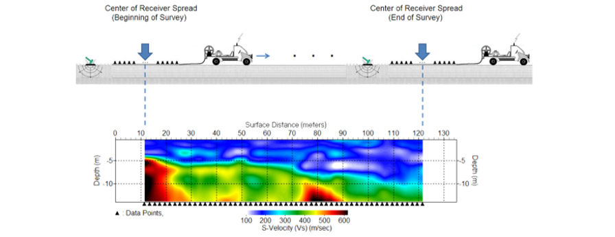
Multi-Channel Analysis of Surface Waves (MASW)
MASW is our premier method for evaluating near-surface ground stiffness and stratigraphy. It uses surface seismic waves to develop 1D and 2D shear wave velocity (Vs) profiles that support geotechnical and structural design efforts.
MASW are conducted from the surface without the need for borings and can:
Analyze the dispersion characteristics of Rayleigh waves to compute shear wave velocity as a function of depth.
Produce 1D velocity-versus-depth profiles and 2D cross sections that highlight changes in soil and rock stiffness.
Provide quantitative input for engineering models, foundation design, and re-evaluation of existing structures.
Quantify soil stiffness mapping for foundations, slabs-on-grade, embankments, and pavement systems.
Identify “soft zones,” potential voids, and anomalous layers beneath pavements, tank pads, machine foundations, and critical structures.
Collect data efficiently over large areas, minimizing disruption to site operations.
Determine seismic site classification (e.g., Vs30) for ground modeling and seismic design requirements.
Assess the condition of existing facilities for settlement concerns.
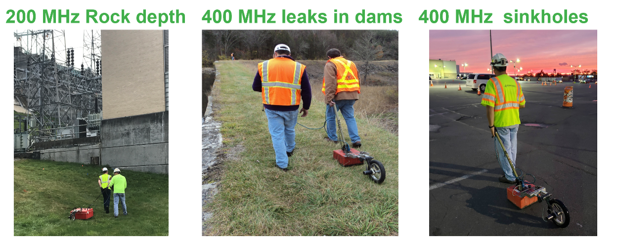
Low-frequency GPR (200 MHz to 900 MHz)
Low-frequency GPR (200 MHz to 900 MHz) is an integral geophysical test method used to better understand subsurface anomalies and locate buried utilities.
Applications include:
Locating utilities (in-service and abandoned)
Locating underground storage tanks (USTs)
Locate Buried and abandoned foundations
Quantify soil subsidence, sinkholes, and breaks in drain pipe systems
Determine void and sediment transport beneath slabs and spillways
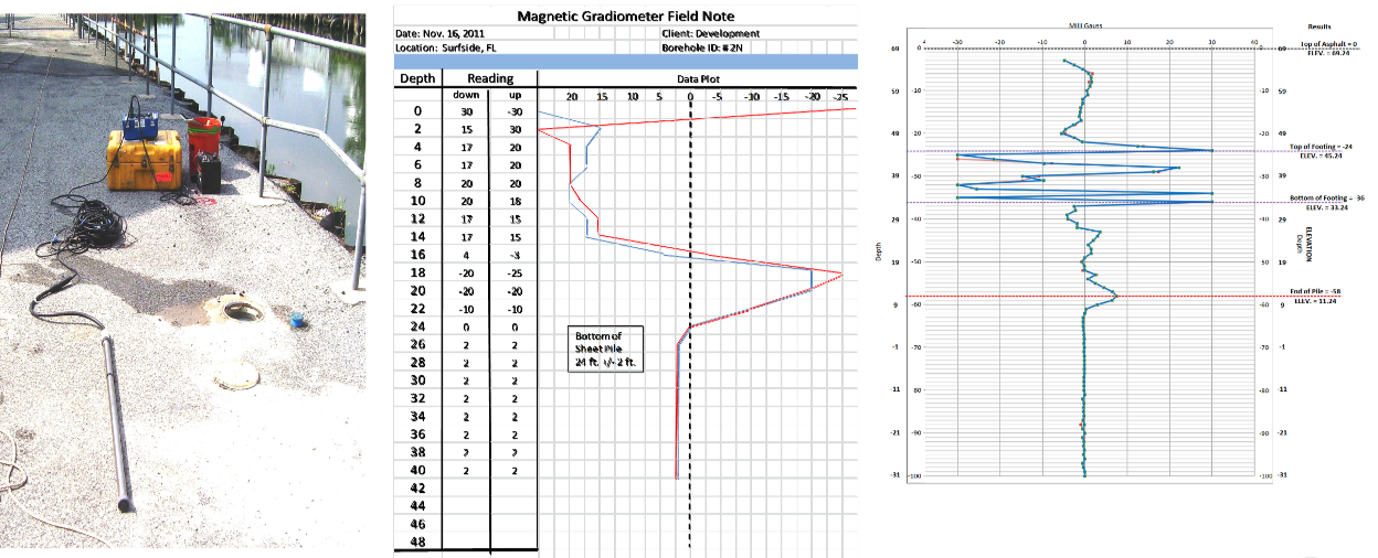
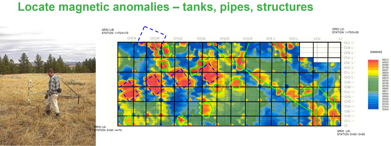
Magnetic Gradiometer
Borehole Gradiometer is a geophysical test method that measures how a magnetic field changes on a metal member (H pile) as the sensor is lowered into a borehole. By looking at the gradient (the rate of change) of the magnetic field strength, it becomes more sensitive to nearby contrasts.
Mainly used to accurately identify the ends of nearby steel piles (H, Sheet, or Pipe).
Requires a 3-inch borehole within 5 feet of the target structure.
The borehole depth must exceed the assumed length of the target to detect the tip.
Experience You Can Rely On
Founded in 1994, NDT has built a reputation for delivering reliable data, practical insight, and responsive service on technically complex projects. Our team combines decades of field experience with advanced testing technologies to produce results that are clear, defensible, and actionable for engineers and owners.